Townland boundaries
in Catholic Parish of Boyle
County Roscommon
Last updated on September 13, 2000
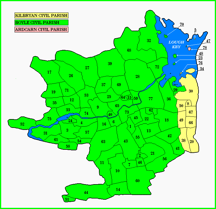
The following list of Townlands are indexed by number as shown in the map above.
1
Aghnagrange
21
Carrownageeragh
41
Grallagh Beg
61
Lecarrow
2
Ardcorcoran
22
Cashelfinoge or Lugnamuddagh
42
Grallagh More
62
Letfordspark
3
Ardmore
23
Church Island
43
Grange Beg
63
Lisserdrea
4
Ardsallagh
24
Coolnagranshy
44
Grange More
64
Lowparks
5
Ash Island
25
Copse
45
Greatmeadow
65
Mocmoyne
6
Ballinphuill
26
Cornaglia
46
Harepark
66
Pollower West
7
Ballybaun
27
Cornameelta
47
Hermit Island
67
Rathdiveen West
8
Ballykeevican
28
Deerpark
48
Hogs Island
68
Sheegorey
9
Ballylugnagon
29
Demesne or Rockingham Demesne
49
Keeloges
69
Spa
10
Ballymore East or Corbally
30
Demesne or Rockingham Demesne
50
Kilbryan
70
Stag Island
11
Ballymore West
31
Derrymaquirk
51
Killerdoo
71
Twanyneden
12
Ballynanultagh
32
Doon
52
Kiltybrannock
72
Tawnytaskin
13
Ballytrasna
33
Drumanone
53
Kiltycreaghtan
73
Termon
14
Behy
34
Drummans Island
54
Knockadoo
74
Tinacarra
15
Bellspark
35
Drumshannagh
55
Knockadoobrusna
75
Tivannagh
16
Breandrum
36
Erris
56
Knockarush
76
Trinity Island
17
Brislagh
37
Evikeens
57
Knockavroe
77
Warren or Drum
18
Carrickmore
38
Fawnanierin
58
Knocknacloy
78
Bullock Island
19
Carrigeenagowna
39
Garrow
59
Knocknashee
20
Carrowmore (West)
40
Glebe
60
Leam
Special thanks to John Hunter for his assistance with getting the above map online
For any additional information regarding the above data,
contact Ed Finn at
efinn@leitrim-roscommon.com
Click
here
to return to the Leitrim-Roscommon home page