Townland boundaries
in Catholic Parish of CROGHAN
[Historic name: Killukin and Killummod]
County Roscommon
Last updated on July 12, 1998

This is pretty useless without graphics

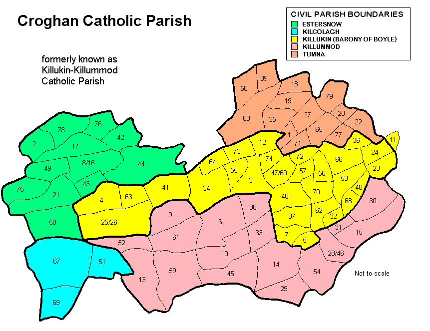
The following list of Townlands are indexed by number as shown in the map above.

1Ardchamoyle21Cloonshaghan41Enagh61Lisdaly
2Ardkeenagh22Cloonskeeveen42Estersnow62Lodge
3Ardlavagh23Cordrehid43Farranagalliagh63Lugnashammer
4Ardmore24Cortober44Faus64Macnadille
5Ballindrehid25Croghan45Finnor65Meera
6Ballinvilla26Croghan Village46Flagford or Culleenatreen66Mullaghmore
7Ballyculleen27Cuiltyconeen47Gardenstown or Legvoy67Ratallen
8Ballynahoogh or Cavetown28Culleenatreen or Flagford  48Glebe68Rock
9Bunreagh29Dacklin49Glooria69Runnaboll
10Canbo30Danesfort50Hughes Town70Scregg
11Carrick on Shannon Town (part of)  31Deerpark51Kilcolagh71Sroankeeragh
12Carroward32Deerpark52Killappoge72Tawlaght
13Carrowmore33Derraun53Killukin (Barony of Boyle)  73Toormore
14Carrowreagh34Derrylow54Killummod74Toorymartin
15Cartron35Dorrary55Knockacorha75Treanagry
16Cavetown or Ballynahoogh36Drishoge56Knockadalteen76Tullyboy
17Clogher37Drumercool57Knockananima77Tullyleague
18Clooneigh38Drumerr58Knocknafushoga78Tullyvohaun
19Cloongownagh39Drumharlow59Knockroe79Tumna
20Cloonmaan40Drumlion60Legvoy or Gardenstown80Woodbrook


Special thanks to Thomas Mullaney, whose book "Croghan - Drumlion, 1884-1984, a history" was the guide for this page


For any additional information regarding the above data,
contact Ed Finn at efinn@leitrim-roscommon.com


Click here to return to the Leitrim-Roscommon home page