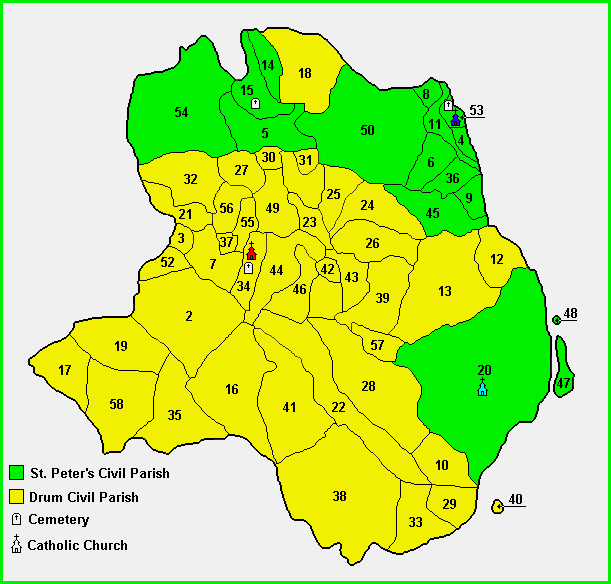
Townland boundaries
in Catholic Parish of Athlone
[Historical name: St. Peter's and Drum]
County Roscommon
Last updated on May 21, 2003

This is pretty useless without graphics

The following list of Townlands are indexed by number as shown in the map above.

1Ardagawna21Cloonrollagh41Johnstown Demesne
2Ardkeenan22Cornafulla42Keeloges
3Ardnanure23Crancarn43Keelty
4Athlone and Big Meadow24Crannagh44Kilmocolmock
5Bellanamullia25Crannagh Beg45Kilnamanagh
6Bellaugh26Crannagh More46Lisdillure
7Belrea27Creagh47Long Island (River Shannon)
8Bogganfin (part of)28Creggan48Long Island Little (River Shannon)  
9Bunnaribba29Cregganabeaka49Mihanboy
10Callowbeg30Cuilglass50Monksland
11Canal and Banks31Cuilleen51Moynure
12Carrickynaghtan32Curraghaleen52Newtown
13Carrickynaghtan and Garrynagawna Bog   33Curraghnaboll53Ranelagh
14Cartron34Curryroe54Rooskagh
15Cloonakille35Dooghan55Taduff East
16Cloonark36Doovoge56Taduff West
17Cloonboley37Drum57Taylorstown
18Cloongowna38Drumlosh58Thomastown Demesne
19Cloonillan39Garrynagawna  
20Cloonown40Inchinalee (Is.) (River Shannon)  


Special thanks to John Hunter for his assistance with obtaining, digitizing and getting the above map online


For any additional information regarding the above data,
contact Ed Finn at efinn@leitrim-roscommon.com


Click here to return to the Leitrim-Roscommon home page