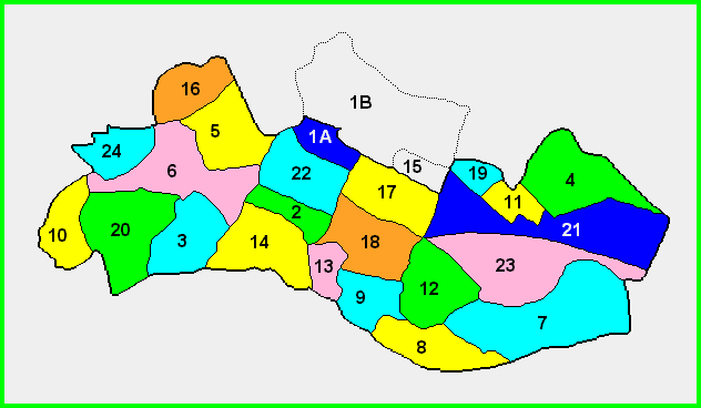
Map of Civil Parish of Bumlin
In County Roscommon
Showing Townland Locations
The following list of Townlands are indexed by number
as shown in the map above.
| 1A | Ballyfeeny (Bumlin) | | 13 | Gortlust |
|---|
| 1B | Ballyfeeny (Kilglass) | | 14 | Graffoge |
|---|
| 2 | Bellanamullia | | 15 | Kilgraffy (Kilglass) |
|---|
| 3 | Bumlin | | 16 | Kilmore |
|---|
| 4 | Cordrumman | | 17 | Killinordan |
|---|
| 5 | Cloonrabrackan | | 18 | Killinordan Beg |
|---|
| 6 | Cloonradoon | | 19 | Monenacully |
|---|
| 7 | Cloonshannagh | | 20 | Newtown |
|---|
| 8 | Culliagh Lower | | 21 | North Yard |
|---|
| 9 | Culliagh Upper | | 22 | Pollymount |
|---|
| 10 | Farnbeg | | 23 | Scramoge |
|---|
| 11 | Garryglass | | 24 | Vesnoy |
|---|
| 12 | Gorttoose | | | |
|---|
|
|---|
NOTICE: This map is based on a series of maps available through
the LDS FHC. Some inconsistencies have been noted between this series of maps and the Alphabetical Index of Towns and
Townlands used for the 1851 census. Some of these inconsistencies are associated with the spelling of various Townlands, while
others inconsistencies are associated with the addition or absence of Townlands referenced in the Alphabetical Index.
As a user of these maps, if you should observe any inconsistencies, please take the time to send an email to Ed Finn at the
email address listed below, and detail your observation. Every effort will be made to make the maps as accurate as possible.
This map is a joint Leitrim-Roscommon/Rootsweb project
Special thanks to David Falion and William Gately for their assistance in making this map available to the researchers at the Leitrim-Roscommon site
Please forward any suggestions or comments on this site to Ed Finn at efinn@leitrim-roscommon.com
Click here to return to the Leitrim-Roscommon home page