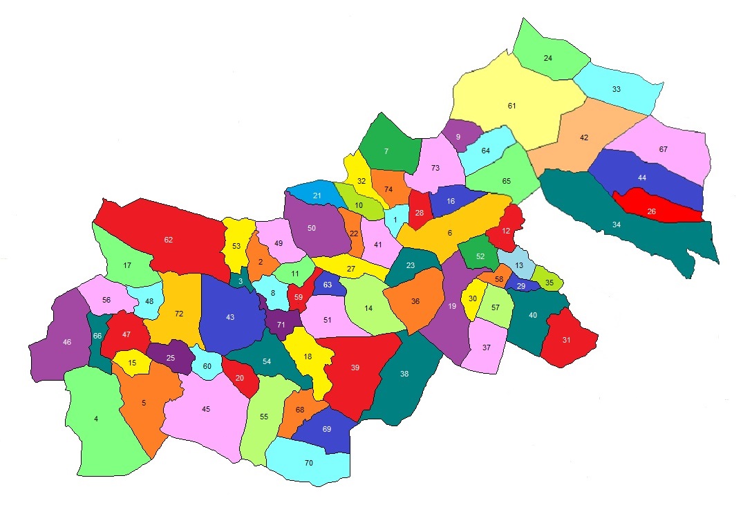
Map of Civil Parish of Kilbeagh
In County Mayo
Showing Townland Locations
 |
|---|
The following list of Townlands are indexed by number
as shown in the map above.
| 1 | Ballintadder | 20 | Cloonalison | 39 | Glenmullynaha West | 58 | Park |
|---|
| 2 | Ballyglass East | 21 | Cloonaweema | 40 | Gortanure | 59 | Puntabeg |
|---|
| 3 | Ballyglass West | 22 | Clooncous | 41 | Gowel | 60 | Ranaranny |
|---|
| 4 | Barnacahoge | 23 | Cloonfane | 42 | Gowlaun | 61 | Roosky |
|---|
| 5 | BarnaLyra | 24 | Cloonlarhan | 43 | Hagfield or Treanacally | 62 | Sonnagh |
|---|
| 6 | Barroe | 25 | Cloonlyon | 44 | Kilgarriff | 63 | Speck |
|---|
| 7 | Botinny | 26 | Cloonmeen East | 45 | Kilgarriff West | 64 | Srah Lower |
|---|
| 8 | Bracklagh | 27 | Cloonmeen West | 46 | Killaturly | 65 | Srah Upper |
|---|
| 9 | Brackloonagh North | 28 | Cloonmore | 47 | Killeen | 66 | Stripe |
|---|
| 10 | Brackloonagh South | 29 | Cragagh | 48 | Knockbrack or Trouthill | 67 | Tawnaghbeg |
|---|
| 11 | Bulcaun | 30 | Cranmore | 49 | Lavy Beg | 68 | Tawnyinab Lower |
|---|
| 12 | Calveagh Lower | 31 | Currinah | 50 | Lavy More | 69 | Tawnyinah Middle |
|---|
| 13 | Calveagh Upper | 32 | Derrydorneen | 51 | Lecarrow | 70 | Tawnyinab Upper |
|---|
| 14 | Cappulcorragh | 33 | Derrykinlough | 52 | Lissymulgee | 71 | Temple |
|---|
| 15 | Carn | 34 | Derrynabrock | 53 | Lowpark | 72 | Tomboholla |
|---|
| 16 | Carrowntober | 35 | Derrynanaff | 54 | Lurga Lower | 73 | Tonnagh |
|---|
| 17 | Cartron | 36 | Fauleens | 55 | Lurga Upper | 74 | Tonroe |
|---|
| 18 | Cashel | 37 | Glastrasna | 56 | Mullenmadoge | | |
|---|
| 19 | Cashelduff | 38 | Glenmullynaha East | 57 | Corragooly | | |
|---|
|
|---|
Please forward any suggestions or comments on this site to Ed Finn at efinn@leitrim-roscommon.com
Click here to return to the Leitrim-Roscommon home page