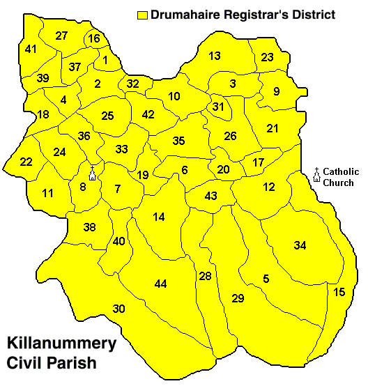
Map of Civil Parish of Killanummery
In County Leitrim
Showing Townland Locations
The following list of Townlands are indexed by number
as shown in the map above.
| 1 | Ardakip Beg | 16 | Creevelea | 31 | Kilcoon |
|---|
| 2 | Ardakip More | 17 | Derrinaher | 32 | Killananima |
|---|
| 3 | Ardvarney | 18 | Derrybrisk | 33 | Killanummery |
|---|
| 4 | Bawn | 19 | Dromore | 34 | Killavoggy |
|---|
| 5 | Beagh | 20 | Drumany | 35 | Killeen |
|---|
| 6 | Caddagh Glebe | 21 | Drumconor | 36 | Mullaghdoo |
|---|
| 7 | Carrigeen | 22 | Drumduff | 37 | Mullanaskeagh |
|---|
| 8 | Carrowcrin | 23 | Drummury | 38 | Rathbaun |
|---|
| 9 | Cashel | 24 | Drumrane | 39 | Sliganagh |
|---|
| 10 | Cleen | 25 | Edergole | 40 | Sracummer |
|---|
| 11 | Cleighran | 26 | Flughanagh | 41 | Sradoon |
|---|
| 12 | Cloonbannive | 27 | Friarstown | 42 | Tully |
|---|
| 13 | Corcusconny | 28 | Garvagh | 43 | Tullycoly |
|---|
| 14 | Corglancey | 29 | Garvagh Glebe | 44 | Tullynascreen |
|---|
|
|---|
Special thanks go out to John Hunter for his support in obtaining, documenting and digitizing this map. As a user of these maps, if you should observe any inconsistencies, please take the time to send an email to John Hunter, and detail your observation. Every effort will be made to make the maps as accurate as possible.
Please forward any suggestions or comments on this site to Ed Finn at efinn@leitrim-roscommon.com
Click here to return to the Leitrim-Roscommon home page