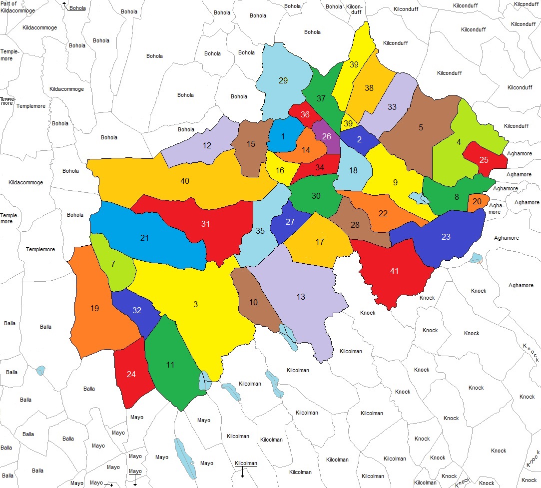
Map of Civil Parish of Killedan
In County Mayo
Showing Townland Locations
The following list of Townlands are indexed by number
as shown in the map above.
| 1 | Annagh Hill | 12 | Carrownteeaun | 23 | Derrykinlough | 34 | Lisnamaneeagh |
|---|
| 2 | Attavally | 13 | Carrowreagh | 24 | Derryvohy | 35 | Oxford |
|---|
| 3 | Ballinamore | 14 | Cartron | 25 | Devleash | 36 | Pollronahan Beg |
|---|
| 4 | Balloorclerhy | 15 | Cloondoolough | 26 | Garryroe | 37 | Pollronahan More |
|---|
| 5 | Ballynamona | 16 | Cloonkedagh | 27 | Gortgarve | 38 | Shanvally |
|---|
| 6 | Brownespark | 17 | Cordarragh | 28 | Gowelboy | 39 | Treankeel |
|---|
| 7 | Camderrynabinnia | 18 | Corrahoor | 29 | Killedan | 40 | Treannagleragh |
|---|
| 8 | Canbrack | 19 | Craggagh | 30 | Kiltamagh | 41 | Woods |
|---|
| 9 | Carrick | 20 | Cuilgar | 31 | Knocknaskeagh | | |
|---|
| 10 | Carrownageeragh | 21 | Cuillalea | 32 | Largan | | |
|---|
| 11 | Carrowndangan | 22 | Cuiltrasna | 33 | Lisduff | | |
|---|
|
|---|
The surrounding townlands have been identified by their Civil Parish name.
The following Civil Parishes are included in no particular order...
| Kilcolman |
|---|
| Mayo |
|---|
| Knock |
|---|
| Aghamore |
|---|
| Kilconduff |
|---|
| Bohola |
|---|
| Kildacommoge |
|---|
| Templemore |
|---|
| Balla
|
|---|
|
|---|
Please forward any suggestions or comments on this site to Ed Finn at efinn@leitrim-roscommon.com
Click here to return to the Leitrim-Roscommon home page