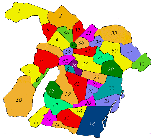
Map of Civil Parish of Moore
In County Roscommon
Showing Townland Locations
The following list of Townlands are indexed by number as shown in the map above.
| 1 | Ardnaglug | | 22 | Cloonburren |
|---|
| 2 | Lowtown Kilcashel | | 23 | Cappantogher |
|---|
| 3 | Cranberry Island | | 24 | Hillsend |
|---|
| 4 | Oldtown Kilcashel | | 25 | America |
|---|
| 5 | Cloonulty | | 26 | Tully |
|---|
| 6 | Rathpeak | | 27 | Moore South |
|---|
| 7 | Kilbegly | | 28 | Clooniff |
|---|
| 8 | Coolderry | | 29 | Cappayuse |
|---|
| 9 | Rooty | | 30 | Cloonbeggaun |
|---|
| 10 | Culliaghmore | | 31 | Derrineel |
|---|
| 11 | Correenbeg | | 32 | Coolumber |
|---|
| 12 | Correen | | 33 | Derrylahan |
|---|
| 13 | Creggan | | 34 | Camcloon |
|---|
| 14 | Raghrabeg | | 35 | Liberty |
|---|
| 15 | Clooneish | | 36 | Toberiheen |
|---|
| 16 | Cloonshask | | 37 | Dolanstown Kilcashel |
|---|
| 17 | Cloonfad | | 38 | Newtown Kilcashel |
|---|
| 18 | Curraghagower | | 39 | Lough Lackagh |
|---|
| 19 | Drumalagagh | | 40 | Ballydangan |
|---|
| 20 | Cornveagh | | 41 | Moore North |
|---|
| 21 | Cappaleitrim | | 42 | Tonvey |
|---|
| | | | 43 | Faltia |
|---|
Special thanks to Allister Hardiman for his assistance in making this map available to the researchers at the Leitrim-Roscommon site
Please forward any suggestions or comments on this site to Ed Finn at efinn@leitrim-roscommon.com
Click here to return to the Leitrim-Roscommon home page
